
Mapa topográfico Thatcham
Mapa interactivo
Haga clic en el mapa para ver la altitud.
Acerca de este mapa
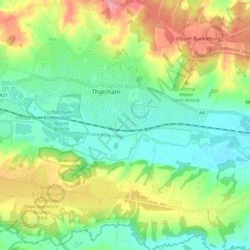
Nombre: Mapa topográfico Thatcham, altitud, relieve.
Lugar: Thatcham, West Berkshire, England, United Kingdom (51.36623 -1.29598 51.42332 -1.20907)
Altitud media: 94 m
Altitud mínima: 58 m
Altitud máxima: 152 m
Otros mapas topográficos
Haga clic en un mapa para ver su topografía, su altitud y su relieve.
Crookham Common
United Kingdom > England > West Berkshire > Thatcham
Crookham Common, Thatcham, West Berkshire, England, RG19 8DD, United Kingdom
Altitud media: 98 m