
Gracias por apoyar a este sitio ❤️
Haz una donación
Haz una donación
Mapa topográfico Corozal
Haga clic en el mapa para ver la altitud.
Gracias por apoyar a este sitio ❤️
Haz una donación
Haz una donación
Acerca de este mapa
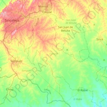
Nombre: Mapa topográfico Corozal, altitud, relieve.
Lugar: Corozal, Sabanas, Sucre, RAP Caribe, Colombia (9.05731 -75.35886 9.35201 -75.12555)
Altitud media: 128 m
Altitud mínima: 54 m
Altitud máxima: 250 m
Gracias por apoyar a este sitio ❤️
Haz una donación
Haz una donación
Otros mapas topográficos
Haga clic en un mapa para ver su topografía, su altitud y su relieve.
Sincelejo
The geography of Sincelejo is characterized by a hilly landscape which extends from the mountains to the borders of the plateau in the north and south. The small mountain foothills in the municipality span from the marine fluvial plain in the west to the border shared with the town of Palmito. Erosion is…
Altitud media: 121 m