
Mapa topográfico Hille
Mapa interactivo
Haga clic en el mapa para ver la altitud.
Acerca de este mapa
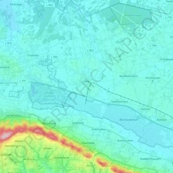
Nombre: Mapa topográfico Hille, altitud, relieve.
Altitud media: 70 m
Altitud mínima: 39 m
Altitud máxima: 309 m
Otros mapas topográficos
Haga clic en un mapa para ver su topografía, su altitud y su relieve.
Minden
Duitsland > Noordrijn-Westfalen > Kreis Minden-Lübbecke
Minden, Kreis Minden-Lübbecke, Noordrijn-Westfalen, Duitsland
Altitud media: 60 m
Porta Westfalica
Duitsland > Noordrijn-Westfalen > Kreis Minden-Lübbecke
Porta Westfalica, Kreis Minden-Lübbecke, Noordrijn-Westfalen, 32457, Duitsland
Altitud media: 85 m