
Mapa topográfico Washington
Mapa interactivo
Haga clic en el mapa para ver la altitud.
Acerca de este mapa
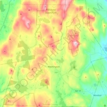
Nombre: Mapa topográfico Washington, altitud, relieve.
Altitud media: 466 m
Altitud mínima: 265 m
Altitud máxima: 742 m
Lovewell Mountain, located northeast of the town center and with an elevation of 2,496 feet (761 m), is the highest point in town. As Edwin A. Charlton writes in New Hampshire As It Is (1855), the mountain "received its name from Captain John Lovewell, who was accustomed to ascend it for the purpose of discovering the wigwams of the Indians, and who, on one occasion, killed seven Indians near its summit." The Washington Town Common, elevation 1,507 feet (459 m), is the highest town center in the state. (The town hall of Clarksville in northern New Hampshire is located at a higher elevation—1,980 feet (600 m)—but there is no other village development there.)
Otros mapas topográficos
Haga clic en un mapa para ver su topografía, su altitud y su relieve.
Croydon
United States > New Hampshire > Sullivan County
Croydon, Sullivan County, New Hampshire, United States
Altitud media: 372 m
Plainfield
United States > New Hampshire > Sullivan County
Plainfield, Sullivan County, New Hampshire, United States
Altitud media: 267 m
Unity
United States > New Hampshire > Sullivan County
Unity, Sullivan County, New Hampshire, United States
Altitud media: 369 m
Lempster
United States > New Hampshire > Sullivan County
Lempster, Sullivan County, New Hampshire, 03605, United States
Altitud media: 425 m
Springfield
United States > New Hampshire > Sullivan County > Springfield
Springfield, Sullivan County, New Hampshire, United States
Altitud media: 416 m
Charlestown
United States > New Hampshire > Sullivan County
Charlestown, Sullivan County, New Hampshire, 03603, United States
Altitud media: 256 m
Claremont
United States > New Hampshire > Sullivan County
Claremont, Sullivan County, New Hampshire, United States
Altitud media: 236 m