
Mapa topográfico Venezuela
Mapa interactivo
Haga clic en el mapa para ver la altitud.
Acerca de este mapa
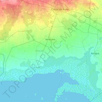
Nombre: Mapa topográfico Venezuela, altitud, relieve.
Lugar: Venezuela, Ciego de Avila, 67800, Cuba (21.52818 -79.02226 21.87207 -78.65660)
Altitud media: 19 m
Altitud mínima: -2 m
Altitud máxima: 81 m
Shaped roughly like a triangle, the country has a 2,800 km (1,700 mi) coastline in the north, which includes numerous islands in the Caribbean and the northeast borders the northern Atlantic Ocean. Most observers describe Venezuela in terms of four fairly well defined topographical regions: the Maracaibo lowlands in the northwest, the northern mountains extending in a broad east–west arc from the Colombian border along the northern Caribbean coast, the wide plains in central Venezuela, and the Guiana Highlands in the southeast.