
Gracias por apoyar a este sitio ❤️
Haz una donación
Haz una donación
Mapa topográfico Guildford
Haga clic en el mapa para ver la altitud.
Gracias por apoyar a este sitio ❤️
Haz una donación
Haz una donación
Acerca de este mapa
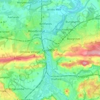
Nombre: Mapa topográfico Guildford, altitud, relieve.
Lugar: Guildford, Surrey, England, GU1 3DP, United Kingdom (51.19561 -0.61321 51.27561 -0.53321)
Altitud media: 64 m
Altitud mínima: 22 m
Altitud máxima: 171 m
Gracias por apoyar a este sitio ❤️
Haz una donación
Haz una donación
Otros mapas topográficos
Haga clic en un mapa para ver su topografía, su altitud y su relieve.
Shalford
United Kingdom > England > Surrey > Guildford > Guildford
Lt.Col. Henry Haversham Godwin-Austen (1834–1923), topographer, geologist, naturalist and explorer who surveyed the Himalayan region, including K2, sometimes known as Mt. Godwin-Austen, for a time had an estate in Shalford.
Altitud media: 54 m
Cranleigh Waters or Bramley Wey
United Kingdom > England > Surrey > Guildford > Shalford
Altitud media: 52 m
Gracias por apoyar a este sitio ❤️
Haz una donación
Haz una donación