
Mapa topográfico Al-Dawayah District
Mapa interactivo
Haga clic en el mapa para ver la altitud.
Acerca de este mapa
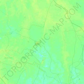
Nombre: Mapa topográfico Al-Dawayah District, altitud, relieve.
Lugar: Al-Dawayah District, Dhi Qar Governorate, 64012, Iraq (31.31659 46.21528 31.68106 46.57822)
Altitud media: 8 m
Altitud mínima: 3 m
Altitud máxima: 13 m
Otros mapas topográficos
Haga clic en un mapa para ver su topografía, su altitud y su relieve.
المعامل الحكومية
المعامل الحكومية, Al-Nasiriyah Central Subdistrict, Al-Nasiriyah District, Dhi Qar Governorate, Iraq
Altitud media: 5 m
Al-Rifa'i District
Al-Rifa'i District, Dhi Qar Governorate, Iraq
Altitud media: 9 m
Al Batha
Al Batha, Al-Batha Subdistrict, Al-Nasiriyah District, Dhi Qar Governorate, Iraq
Altitud media: 8 m
Tell el-'Oueili
Iraq > Dhi Qar Governorate > Al-Rifa'i District
Tell el-'Oueili, الطريق بغداد - البصرة, Al-Nasr Subdistrict, Al-Rifa'i District, Al-Batha Subdistrict, Al-Nasiriyah District, Dhi Qar Governorate, Iraq
Altitud media: 7 m
Euphrates
Iraq > Dhi Qar Governorate > Nasiriyah
Euphrates, Nasiriyah, Al-Nasiriyah Central Subdistrict, Al-Nasiriyah District, Dhi Qar Governorate, Iraq
Altitud media: 6 m
Qaryat al Karush
Iraq > Dhi Qar Governorate > Qaryat al Karush
Qaryat al Karush, Al-Nasiriyah Central Subdistrict, Al-Nasiriyah District, Dhi Qar Governorate, Iraq
Altitud media: 5 m
Jamaat ash Shaykh
Iraq > Dhi Qar Governorate > Harran as Sajit > Jamaat ash Shaykh
Jamaat ash Shaykh, Harran as Sajit, Al-Dawayah Central Subdistrict, Al-Dawayah District, Dhi Qar Governorate, Iraq
Altitud media: 7 m
Al Kurmashiyah ash Sharqiyah
Iraq > Dhi Qar Governorate > Al Kurmashiyah ash Sharqiyah
Al Kurmashiyah ash Sharqiyah, Karmat Bani Saad Subdsitrict, Sooq Ash-Shuyookh District, Dhi Qar Governorate, Iraq
Altitud media: 4 m