
Mapa topográfico Keban
Mapa interactivo
Haga clic en el mapa para ver la altitud.
Acerca de este mapa
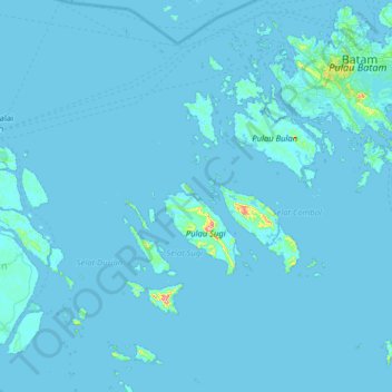
Nombre: Mapa topográfico Keban, altitud, relieve.
Lugar: Keban, Batam City, Riau Islands, Indonesia (0.56000 103.45056 1.20000 104.09056)
Altitud media: 4 m
Altitud mínima: -2 m
Altitud máxima: 265 m
Otros mapas topográficos
Haga clic en un mapa para ver su topografía, su altitud y su relieve.
Lubuk Baja Kota
Indonesia > Riau Islands > Batam City
Lubuk Baja Kota, Batam City, Riau Islands, Sumatra, 29443, Indonesia
Altitud media: 18 m
Teluk Tering
Indonesia > Riau Islands > Batam City > Teluk Tering
Teluk Tering, Batam City, Riau Islands, 24961, Indonesia
Altitud media: 13 m
Taman Seruni Indah
Indonesia > Riau Islands > Batam City
Taman Seruni Indah, Batam City, Riau Islands, 29456, Indonesia
Altitud media: 16 m