
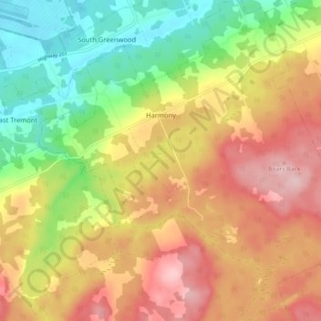
Mapa topográfico Harmony
Mapa interactivo
Haga clic en el mapa para ver la altitud.
Acerca de este mapa
Nombre: Mapa topográfico Harmony, altitud, relieve.
Altitud media: 129 m
Altitud mínima: 23 m
Altitud máxima: 234 m
Otros mapas topográficos
Haga clic en un mapa para ver su topografía, su altitud y su relieve.
Aylesford
Canada > Nova Scotia > Municipality of the County of Kings
Aylesford, Municipality of the County of Kings, Kings County, Nova Scotia, B0P 1C0, Canada
Altitud media: 30 m
Tremont
Canada > Nova Scotia > Municipality of the County of Kings
Tremont, Municipality of the County of Kings, Kings County, Nova Scotia, B0P 1R0, Canada
Altitud media: 58 m
Bishopville
Canada > Nova Scotia > Municipality of the County of Kings
Bishopville, Municipality of the County of Kings, Kings County, Nova Scotia, B0P 1P0, Canada
Altitud media: 88 m
Greenwich
Canada > Nova Scotia > Municipality of the County of Kings
Greenwich, Municipality of the County of Kings, Kings County, Nova Scotia, B4P 0B2, Canada
Altitud media: 32 m
Kingston
Canada > Nova Scotia > Municipality of the County of Kings
Kingston, Municipality of the County of Kings, Kings County, Nova Scotia, B0P 1R0, Canada
Altitud media: 30 m
Steam Mill
Canada > Nova Scotia > Municipality of the County of Kings
Steam Mill, Municipality of the County of Kings, Kings County, Nova Scotia, Canada
Altitud media: 22 m
East Margaretsville
Canada > Nova Scotia > Municipality of the County of Kings
East Margaretsville, Municipality of the County of Kings, Kings County, Nova Scotia, B0P 1R0, Canada
Altitud media: 91 m
Lumsden Pond
Canada > Nova Scotia > Municipality of the County of Kings > Lumsden Dam
Lumsden Pond, Lumsden Dam, Municipality of the County of Kings, Kings County, Nova Scotia, Canada
Altitud media: 170 m
Armstrong Lake
Canada > Nova Scotia > Municipality of the County of Kings
Armstrong Lake, Municipality of the County of Kings, Kings County, Nova Scotia, Canada
Altitud media: 208 m
Hortonville
Canada > Nova Scotia > Municipality of the County of Kings
Hortonville, Municipality of the County of Kings, Kings County, Nova Scotia, Canada
Altitud media: 16 m
Salmontail Lake
Canada > Nova Scotia > Municipality of the County of Kings
Salmontail Lake, Municipality of the County of Kings, Kings County, Nova Scotia, Canada
Altitud media: 226 m
Blue Mountain
Canada > Nova Scotia > Municipality of the County of Kings
Blue Mountain, Municipality of the County of Kings, Kings County, Nova Scotia, B4N 3V8, Canada
Altitud media: 224 m
Greenwood
Canada > Nova Scotia > Municipality of the County of Kings
Greenwood, Municipality of the County of Kings, Kings County, Nova Scotia, B0P 1N0, Canada
Altitud media: 28 m
Grand Pre
Canada > Nova Scotia > Municipality of the County of Kings
Grand Pre, Municipality of the County of Kings, Kings County, Nova Scotia, B0P 1M0, Canada
Altitud media: 21 m
North Kingston
Canada > Nova Scotia > Municipality of the County of Kings
North Kingston, Municipality of the County of Kings, Kings County, Nova Scotia, B0P 1R0, Canada
Altitud media: 88 m
Bishopville
Canada > Nova Scotia > Municipality of the County of Kings
Bishopville, Municipality of the County of Kings, Kings County, Nova Scotia, B0P 1P0, Canada
Altitud media: 81 m
Kingsport
Canada > Nova Scotia > Municipality of the County of Kings
Kingsport, Municipality of the County of Kings, Kings County, Nova Scotia, B0P 1T0, Canada
Altitud media: 9 m
Halls Harbour
Canada > Nova Scotia > Municipality of the County of Kings
Halls Harbour, Municipality of the County of Kings, Kings County, Nova Scotia, Canada
Altitud media: 79 m
Frog Lake
Canada > Nova Scotia > Municipality of the County of Kings
Frog Lake, Municipality of the County of Kings, Kings County, Nova Scotia, Canada
Altitud media: 211 m
Factorydale
Canada > Nova Scotia > Municipality of the County of Kings
Factorydale, Municipality of the County of Kings, Kings County, Nova Scotia, B0P 1E0, Canada
Altitud media: 43 m
Gaspereau
Canada > Nova Scotia > Municipality of the County of Kings
Gaspereau, Municipality of the County of Kings, Kings County, Nova Scotia, B4P 2R1, Canada
Altitud media: 113 m