Mapa topográfico Logan
Mapa interactivo
Haga clic en el mapa para ver la altitud.
Acerca de este mapa
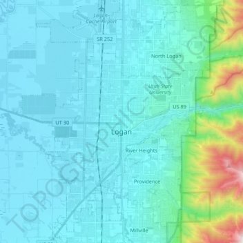
Nombre: Mapa topográfico Logan, altitud, relieve.
Lugar: Logan, Cache County, Utah, United States (41.67538 -111.90194 41.79736 -111.78019)
Altitud media: 1.498 m
Altitud mínima: 1.342 m
Altitud máxima: 2.659 m
The city lies near the eastern edge of Cache Valley on the western slopes of the Bear River Mountains. Mount Logan rises to an elevation of 9,710 feet (2,960 m) immediately to the east, and south of Logan Canyon. The eastern portions of the city are constructed on top of shelf-like "benches", late Pleistocene sedimentary deposits created by the glacially fed Logan River feeding into the northern stretches of Lake Bonneville, building a "Gilbert-type" river delta over several thousand years. The Logan River later cut down through these sedimentary deposits following the draining of Lake Bonneville approximately 14,500 years ago. This created a low-lying area with very steep slopes that reach into the rest of town and to the Logan River bottomlands. To the west of Logan lie flatlands that contain both farmland and marshes. To the north and south of Logan are rapidly growing residential suburbs.
Otros mapas topográficos
Haga clic en un mapa para ver su topografía, su altitud y su relieve.
Trenton
United States > Utah > Cache County
Trenton, Cache County, Utah, 84338, United States
Altitud media: 1.392 m
Benson
United States > Utah > Cache County
Benson, Cache County, Utah, United States
Altitud media: 1.442 m
Peter
United States > Utah > Cache County > Petersboro
Peter, Petersboro, Cache County, Utah, United States
Altitud media: 1.445 m
Lewiston
United States > Utah > Cache County
Lewiston, Cache County, Utah, 84320, United States
Altitud media: 1.376 m
Hyrum
United States > Utah > Cache County
Hyrum, Cache County, Utah, 84319, United States
Altitud media: 1.439 m
Clarkston
United States > Utah > Cache County
Clarkston, Cache County, Utah, 84305, United States
Altitud media: 1.498 m
River Heights
United States > Utah > Cache County
River Heights, Cache County, Utah, United States
Altitud media: 1.395 m
Mendon
United States > Utah > Cache County
Mendon, Cache County, Utah, United States
Altitud media: 1.399 m
Smithfield
United States > Utah > Cache County
Smithfield, Cache County, Utah, 84335, United States
Altitud media: 1.404 m
Mount Pisgah
United States > Utah > Cache County
Mount Pisgah, Cache County, Utah, United States
Altitud media: 1.862 m
Logan Canyon
United States > Utah > Cache County
Logan Canyon, Cache County, Utah, 84322, United States
Altitud media: 1.780 m
Nibley
United States > Utah > Cache County
Nibley, Cache County, Utah, United States
Altitud media: 1.428 m
Logan River
United States > Utah > Cache County
Logan River, Cache County, Utah, United States
Altitud media: 1.919 m
Providence Canyon
United States > Utah > Cache County
Providence Canyon, Cache County, Utah, 84332, United States
Altitud media: 1.829 m
Wellsville
United States > Utah > Cache County
Wellsville, Cache County, Utah, 84339, United States
Altitud media: 1.545 m
Logan
United States > Utah > Cache County > Logan > Logan
Logan, Cache County, Utah, 84321, United States
Altitud media: 1.419 m
Hyde Park
United States > Utah > Cache County
Hyde Park, Cache County, Utah, 84318, United States
Altitud media: 1.418 m
North Logan
United States > Utah > Cache County
North Logan, Cache County, Utah, 84341, United States
Altitud media: 1.487 m
Hyrum
United States > Utah > Cache County > Hyrum > Hyrum
Hyrum, Cache County, Utah, 84319-1660, United States
Altitud media: 1.439 m
Peter Sinks
United States > Utah > Cache County
Peter Sinks, Cache County, Utah, United States
Altitud media: 2.555 m
Providence
United States > Utah > Cache County
Providence, Cache County, Utah, 84332, United States
Altitud media: 1.434 m
James Peak
United States > Utah > Cache County
James Peak, Cache County, Utah, United States
Altitud media: 2.550 m