
Gracias por apoyar a este sitio ❤️
Haz una donación
Haz una donación
Mapa topográfico Bailey
Haga clic en el mapa para ver la altitud.
Gracias por apoyar a este sitio ❤️
Haz una donación
Haz una donación
Acerca de este mapa
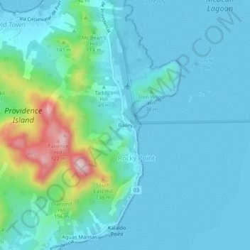
Nombre: Mapa topográfico Bailey, altitud, relieve.
Lugar: Bailey, Rocky Point, San Andrés and Providencia, Colombia (13.33158 -81.37820 13.37158 -81.33820)
Altitud media: 56 m
Altitud mínima: 0 m
Altitud máxima: 345 m
Gracias por apoyar a este sitio ❤️
Haz una donación
Haz una donación
Otros mapas topográficos
Haga clic en un mapa para ver su topografía, su altitud y su relieve.
Providence Island
Colombia > San Andrés and Providencia > Rocky Point
Providencia's maximum elevation is 360 metres (1,180 ft) above sea level. The smaller Santa Catalina Island to the northwest is connected by a 100-metre (330 ft) footbridge to its larger sister Providencia Island. Providencia Island has an area of 17 square kilometres (6.6 sq mi); the two islands cover an area…
Altitud media: 33 m