
Gracias por apoyar a este sitio ❤️
Haz una donación
Haz una donación
Mapa topográfico Mont Ventoux
Haga clic en el mapa para ver la altitud.
Gracias por apoyar a este sitio ❤️
Haz una donación
Haz una donación
Mont Ventoux
There are two small ski stations on the mountain: "Mont Serein" on the north side, and "Chalet Reynard" on the south. High winds and the modest elevation tend to limit the ski season. Weather conditions are such that the northern slope is often icy, leading to a saying among people of the surrounding region regarding the challenges of skiing the mountain: Qui skie au Ventoux, skie partout (If you can ski Ventoux, you can ski anywhere).
Gracias por apoyar a este sitio ❤️
Haz una donación
Haz una donación
Acerca de este mapa
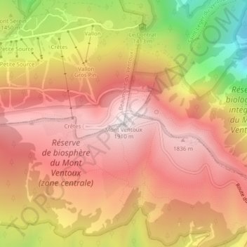
Nombre: Mapa topográfico Mont Ventoux, altitud, relieve.
Altitud media: 1.557 m
Altitud mínima: 945 m
Altitud máxima: 1.905 m
Gracias por apoyar a este sitio ❤️
Haz una donación
Haz una donación