
Haz una donación
Mapa topográfico Avignon
Haga clic en el mapa para ver la altitud.
Haz una donación
Avignon
Enclosed by the city walls, the Rocher des Doms is a limestone elevation of Urgonian type, 35 metres high (and therefore safe from flooding of the Rhone which it overlooks) and is the original core of the city. Several limestone massifs are present around the commune (the Massif des Angles, Villeneuve-lès-Avignon, Alpilles...) and they are partly the result of the oceanisation of the Ligurian-Provençal basin following the migration of the Sardo-Corsican block.
Haz una donación
Acerca de este mapa
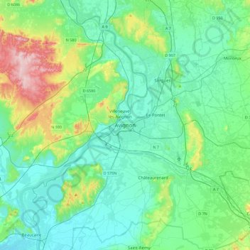
Nombre: Mapa topográfico Avignon, altitud, relieve.
Altitud media: 58 m
Altitud mínima: 3 m
Altitud máxima: 273 m
Haz una donación
Otros mapas topográficos
Haga clic en un mapa para ver su topografía, su altitud y su relieve.
Le Rhône - Bras Mort de la Barthelasse
France > Provence-Alpes-Côte d'Azur > Vaucluse > Avignon
Altitud media: 24 m