
Mapa topográfico Sparta Township
Mapa interactivo
Haga clic en el mapa para ver la altitud.
Acerca de este mapa
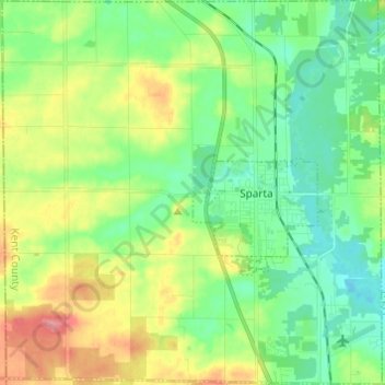
Nombre: Mapa topográfico Sparta Township, altitud, relieve.
Lugar: Sparta Township, Kent County, Michigan, 49345, United States (43.11661 -85.79059 43.20527 -85.67025)
Altitud media: 246 m
Altitud mínima: 217 m
Altitud máxima: 301 m
Otros mapas topográficos
Haga clic en un mapa para ver su topografía, su altitud y su relieve.
Grand Rapids
United States > Michigan > Kent County
Grand Rapids, Kent County, Michigan, United States
Altitud media: 216 m
Cannonsburg
United States > Michigan > Kent County > Cannon Township
Cannonsburg, Cannon Township, Kent County, Michigan, 49317, United States
Altitud media: 256 m
Scram Lake
United States > Michigan > Kent County
Scram Lake, Oakfield Township, Kent County, Michigan, United States
Altitud media: 270 m
Rockford
United States > Michigan > Kent County
Rockford, Kent County, Michigan, 49351, United States
Altitud media: 239 m
Walker
United States > Michigan > Kent County
Walker, Kent County, Michigan, United States
Altitud media: 209 m
Comstock Park
United States > Michigan > Kent County > Plainfield Charter Township
Comstock Park, Plainfield Charter Township, Kent County, Michigan, United States
Altitud media: 206 m
Forest Hills
United States > Michigan > Kent County > Ada Township
Forest Hills, Ada Township, Kent County, Michigan, United States
Altitud media: 229 m
Northview
United States > Michigan > Kent County > Plainfield Charter Township
Northview, Plainfield Charter Township, Kent County, Michigan, United States
Altitud media: 216 m
Wyoming
United States > Michigan > Kent County
Wyoming, Kent County, Michigan, United States
Altitud media: 204 m
Cordes Lake
United States > Michigan > Kent County
Cordes Lake, Courtland Township, Kent County, Michigan, United States
Altitud media: 275 m
Kentwood
United States > Michigan > Kent County
Kentwood, Kent County, Michigan, United States
Altitud media: 216 m
East Grand Rapids
United States > Michigan > Kent County
East Grand Rapids, Kent County, Michigan, 49506, United States
Altitud media: 232 m
Solon Township
United States > Michigan > Kent County
Solon Township, Kent County, Michigan, United States
Altitud media: 263 m
Gaines Township
United States > Michigan > Kent County
Gaines Township, Kent County, Michigan, 49316, United States
Altitud media: 243 m
Vergennes Township
United States > Michigan > Kent County
Vergennes Township, Kent County, Michigan, United States
Altitud media: 242 m
Byron Center
United States > Michigan > Kent County > Byron Center
Byron Center, Byron Township, Kent County, Michigan, United States
Altitud media: 225 m
Alton
United States > Michigan > Kent County > Vergennes Township
Alton, Vergennes Township, Kent County, Michigan, United States
Altitud media: 254 m
Tyrone Township
United States > Michigan > Kent County
Tyrone Township, Kent County, Michigan, 49330, United States
Altitud media: 249 m
Ada Township
United States > Michigan > Kent County
Ada Township, Kent County, Michigan, United States
Altitud media: 228 m
Cascade Charter Township
United States > Michigan > Kent County
Cascade Charter Township, Kent County, Michigan, 49546, United States
Altitud media: 229 m
Ratigan Lake
United States > Michigan > Kent County > Cannon Township
Ratigan Lake, Cannon Township, Grattan Township, Kent County, Michigan, United States
Altitud media: 260 m
Ada
United States > Michigan > Kent County > Ada Township
Ada, Ada Township, Kent County, Michigan, 49355, United States
Altitud media: 208 m
Alto
United States > Michigan > Kent County
Alto, Bowne Township, Kent County, Michigan, United States
Altitud media: 252 m
Lake Leota
United States > Michigan > Kent County > Walker
Lake Leota, Walker, Kent County, Michigan, United States
Altitud media: 199 m
Alaska
United States > Michigan > Kent County
Alaska, Caledonia Township, Kent County, Michigan, United States
Altitud media: 230 m
Grandville
United States > Michigan > Kent County
Grandville, Kent County, Michigan, 49418, United States
Altitud media: 193 m
Caledonia
United States > Michigan > Kent County > Caledonia Charter Township
Caledonia, Caledonia Charter Township, Kent County, Michigan, United States
Altitud media: 243 m
Kentwood
United States > Michigan > Kent County > Kentwood
Kentwood, Kent County, Michigan, 49548, United States
Altitud media: 218 m
Lowell
United States > Michigan > Kent County
Lowell, Kent County, Michigan, United States
Altitud media: 206 m
Cedar Springs
United States > Michigan > Kent County
Cedar Springs, Kent County, Michigan, 49319, United States
Altitud media: 262 m
Byron Township
United States > Michigan > Kent County
Byron Township, Kent County, Michigan, 49315, United States
Altitud media: 221 m
Sand Lake
United States > Michigan > Kent County
Sand Lake, Nelson Township, Kent County, Michigan, United States
Altitud media: 277 m