
Mapa topográfico Mount Harrison
Mapa interactivo
Haga clic en el mapa para ver la altitud.
Acerca de este mapa
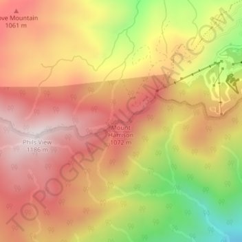
Nombre: Mapa topográfico Mount Harrison, altitud, relieve.
Lugar: Mount Harrison, Sevier County, Tennessee, USA (35.69691 -83.57273 35.69701 -83.57263)
Altitud media: 927 m
Altitud mínima: 541 m
Altitud máxima: 1.176 m
Otros mapas topográficos
Haga clic en un mapa para ver su topografía, su altitud y su relieve.
Falling Water
USA > Tennessee > Falling Water
Falling Water, Hamilton County, Tennessee, USA
Altitud media: 323 m
Grasslands
USA > Tennessee > Grasslands
Grasslands, Montgomery County, Tennessee, 37040, USA
Altitud media: 142 m
Pigeon Forge
USA > Tennessee > Pigeon Forge
Pigeon Forge, Sevier County, Tennessee, USA
Altitud media: 370 m
Panther Creek State Park
Panther Creek State Park, Lake Park, Hamblen County, Tennessee, USA
Altitud media: 347 m
Forty Five
USA > Tennessee > Forty Five
Forty Five, Fayette County, Tennessee, USA
Altitud media: 139 m
Bluff Springs
USA > Tennessee > Bluff Springs
Bluff Springs, Warren County, Tennessee, 37166:38581, USA
Altitud media: 305 m
The Swamps
USA > Tennessee > Mount Denson
The Swamps, Hyde Road, Mount Denson, Robertson County, Tennessee, 37172, USA
Altitud media: 216 m