
Mapa topográfico Valle de Bravo
Mapa interactivo
Haga clic en el mapa para ver la altitud.
Acerca de este mapa
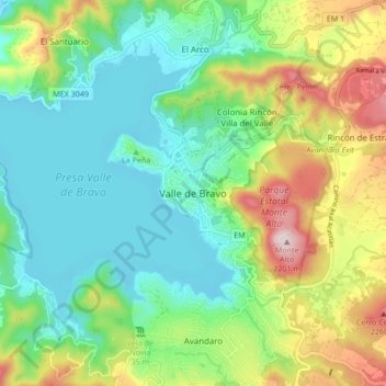
Nombre: Mapa topográfico Valle de Bravo, altitud, relieve.
Lugar: Valle de Bravo, State of Mexico, 51200, Mexico (19.15426 -100.17166 19.23426 -100.09166)
Altitud media: 1.914 m
Altitud mínima: 1.773 m
Altitud máxima: 2.216 m
The municipality is surrounded by mountain ranges and other elevated areas covering about 50% of the total area and include the Sierra de Temascaltepec, Sierra de Tenayac, Sierra de Valle de Bravos as wells as the hills that roll around the mountain ranges. These elevations include a number of small volcanoes such as the "Cerro Gordo". 30% of the area is semi-flat with only 20% of the surface being plains. The main river of the area is the Río Balsas, whose system includes the tributaries of El Salto, Barranca Honda, Tiloxtoc rivers.