
Gracias por apoyar a este sitio ❤️
Haz una donación
Haz una donación
Mapa topográfico Arnhem
Haga clic en el mapa para ver la altitud.
Gracias por apoyar a este sitio ❤️
Haz una donación
Haz una donación
Acerca de este mapa
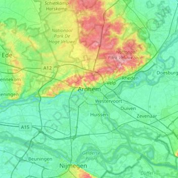
Nombre: Mapa topográfico Arnhem, altitud, relieve.
Lugar: Arnhem, Gelderland, Netherlands, 6811AL, Netherlands (51.82426 5.75086 52.14426 6.07086)
Altitud media: 24 m
Altitud mínima: 2 m
Altitud máxima: 105 m
Gracias por apoyar a este sitio ❤️
Haz una donación
Haz una donación
Otros mapas topográficos
Haga clic en un mapa para ver su topografía, su altitud y su relieve.