
Haz una donación
Mapa topográfico Lorgues
Haga clic en el mapa para ver la altitud.
Haz una donación
Lorgues
In terms of geology Lorgues is, for the most part, underlain by Triassic and Jurassic limestones which give rise to gentle hills and narrow flat-bottomed valleys, the most important of which are the valleys of the rivers Argens and Florièye which border the commune on the south and east. The town centre stands at an elevation of 210m, with the hill of Saint Ferréol to the east rising to 320m.
Haz una donación
Acerca de este mapa
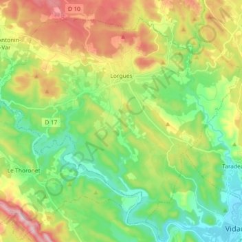
Nombre: Mapa topográfico Lorgues, altitud, relieve.
Altitud media: 189 m
Altitud mínima: 50 m
Altitud máxima: 428 m
Haz una donación
Otros mapas topográficos
Haga clic en un mapa para ver su topografía, su altitud y su relieve.
Haz una donación
Ruines du Barrage de Malpasset
France > Provence-Alpes-Côte d'Azur > Var > Fréjus
Altitud media: 118 m
Haz una donación
Haz una donación
Haz una donación
Haz una donación
Les Aires Longues
France > Provence-Alpes-Côte d'Azur > Var > Ginasservis > Les Aires Longues
Altitud media: 411 m
Draguignan
France > Provence-Alpes-Côte d'Azur > Var > Draguignan > Draguignan
The elevation is 200 m. The highest hill near Draguignan is Malmont (551 m). The main river near Draguignan is the Nartuby.
Altitud media: 288 m
Île des Embiez
France > Provence-Alpes-Côte d'Azur > Var > Six-Fours-les-Plages > Le Brusc
Altitud media: 2 m
Haz una donación
Jospeh Allet
France > Provence-Alpes-Côte d'Azur > Var > Draguignan > Draguignan > Saint François
Altitud media: 207 m
Haz una donación