
Mapa topográfico Boone County
Mapa interactivo
Haga clic en el mapa para ver la altitud.
Acerca de este mapa
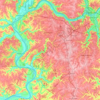
Nombre: Mapa topográfico Boone County, altitud, relieve.
Lugar: Boone County, Kentucky, United States (38.77725 -84.89739 39.14780 -84.59797)
Altitud media: 224 m
Altitud mínima: 136 m
Altitud máxima: 293 m
Otros mapas topográficos
Haga clic en un mapa para ver su topografía, su altitud y su relieve.
Louisville
United States > Kentucky > Jefferson County
Louisville, Jefferson County, Kentucky, United States
Altitud media: 188 m
Bowling Green
United States > Kentucky > Warren County
Bowling Green, Warren County, Kentucky, 42101, United States
Altitud media: 169 m
Paducah
United States > Kentucky > McCracken County
Paducah, McCracken County, Kentucky, United States
Altitud media: 108 m
Owensboro
United States > Kentucky > Daviess County
Owensboro, Daviess County, Kentucky, United States
Altitud media: 123 m
Rockcastle County
Rockcastle County, Kentucky, United States
Altitud media: 348 m
Hindman
United States > Kentucky > Knott County
Hindman, Knott County, Kentucky, United States
Altitud media: 388 m
Frankfort
United States > Kentucky > Franklin County
Frankfort, Franklin County, Kentucky, United States
Altitud media: 216 m
Somerset
United States > Kentucky > Pulaski County
Somerset, Pulaski County, Kentucky, 42503, United States
Altitud media: 295 m
Walker
United States > Kentucky > Knox County
Walker, Knox County, Kentucky, 40997, United States
Altitud media: 403 m
Little Pilot Knob
United States > Kentucky > Wayne County
Little Pilot Knob, Wayne County, Kentucky, United States
Altitud media: 374 m
Lexington
United States > Kentucky > Lexington
Lexington, Fayette County, Kentucky, 40508, United States
Altitud media: 285 m
Balltown
United States > Kentucky > Whitley County > Williamsburg
Balltown, Williamsburg, Whitley County, Kentucky, 40769, United States
Altitud media: 332 m
Monticello
United States > Kentucky > Wayne County
Monticello, Wayne County, Kentucky, 42633, United States
Altitud media: 304 m
Shepherdsville
United States > Kentucky > Bullitt County
Shepherdsville, Bullitt County, Kentucky, United States
Altitud media: 148 m
Danville
United States > Kentucky > Boyle County
Danville, Boyle County, Kentucky, United States
Altitud media: 290 m
Newport
United States > Kentucky > Campbell County
Newport, Campbell County, Kentucky, 41071, United States
Altitud media: 173 m
Pathfork
United States > Kentucky > Harlan County
Pathfork, Harlan County, Kentucky, 40863, United States
Altitud media: 534 m
Lenarue
United States > Kentucky > Harlan County
Lenarue, Harlan County, Kentucky, 40818, United States
Altitud media: 519 m
Paint Lick
United States > Kentucky > Garrard County
Paint Lick, Garrard County, Kentucky, 40461, United States
Altitud media: 272 m
Hustonville
United States > Kentucky > Lincoln County
Hustonville, Lincoln County, Kentucky, United States
Altitud media: 316 m
Lone Star
United States > Kentucky > Hart County
Lone Star, Hart County, Kentucky, 42713, United States
Altitud media: 228 m
Sonora
United States > Kentucky > Hardin County
Sonora, Hardin County, Kentucky, United States
Altitud media: 221 m
Load
United States > Kentucky > Greenup County
Load, Greenup County, Kentucky, United States
Altitud media: 222 m
Bardo
United States > Kentucky > Harlan County
Bardo, Harlan County, Kentucky, 40830, United States
Altitud media: 634 m
Holmes Mill
United States > Kentucky > Harlan County
Holmes Mill, Harlan County, Kentucky, 40843, United States
Altitud media: 758 m
Pansy
United States > Kentucky > Harlan County
Pansy, Harlan County, Kentucky, 40830, United States
Altitud media: 602 m
Putney
United States > Kentucky > Harlan County
Putney, Harlan County, Kentucky, 40865, United States
Altitud media: 601 m
Boyd
United States > Kentucky > Harrison County
Boyd, Harrison County, Kentucky, 41003, United States
Altitud media: 214 m
Uno
United States > Kentucky > Hart County
Uno, Hart County, Kentucky, United States
Altitud media: 201 m
Elkhorn City
United States > Kentucky > Pike County
Elkhorn City, Pike County, Kentucky, United States
Altitud media: 364 m
Walnut Hill
United States > Kentucky > Fayette County > Lexington
Walnut Hill, Lexington, Fayette County, Kentucky, 40509, United States
Altitud media: 311 m
Lexington
United States > Kentucky > Fayette County
Lexington, Fayette County, Kentucky, United States
Altitud media: 281 m
Sparrow
United States > Kentucky > Anderson County
Sparrow, Anderson County, Kentucky, United States
Altitud media: 230 m
Hardyville
United States > Kentucky > Hart County
Hardyville, Hart County, Kentucky, United States
Altitud media: 212 m
Inez
United States > Kentucky > Martin County
Inez, Martin County, Kentucky, 41224, United States
Altitud media: 253 m
Alva
United States > Kentucky > Harlan County
Alva, Harlan County, Kentucky, 40863, United States
Altitud media: 652 m
Yancey
United States > Kentucky > Harlan County
Yancey, Harlan County, Kentucky, 40830, United States
Altitud media: 651 m
Leesburg
United States > Kentucky > Harrison County
Leesburg, Harrison County, Kentucky, United States
Altitud media: 280 m
Jonesville
United States > Kentucky > Hart County
Jonesville, Hart County, Kentucky, 42757, United States
Altitud media: 241 m
Frost
United States > Kentucky > Greenup County
Frost, Greenup County, Kentucky, 41175, United States
Altitud media: 180 m
Land Between the Lakes National Recreation Area
United States > Kentucky > Trigg County
Land Between the Lakes National Recreation Area, Trigg County, Kentucky, United States
Altitud media: 146 m
Fresh Meadows
United States > Kentucky > Harlan County
Fresh Meadows, Harlan County, Kentucky, 40824, United States
Altitud media: 462 m
Pine Mountain
United States > Kentucky > Harlan County
Pine Mountain, Harlan County, Kentucky, United States
Altitud media: 536 m
Kenvir
United States > Kentucky > Harlan County
Kenvir, Harlan County, Kentucky, 40847, United States
Altitud media: 642 m
Ages
United States > Kentucky > Harlan County
Ages, Harlan County, Kentucky, 40801, United States
Altitud media: 587 m