
Gracias por apoyar a este sitio ❤️
Haz una donación
Haz una donación
Mapa topográfico San Agustin
Haga clic en el mapa para ver la altitud.
Gracias por apoyar a este sitio ❤️
Haz una donación
Haz una donación
Acerca de este mapa
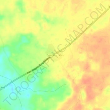
Nombre: Mapa topográfico San Agustin, altitud, relieve.
Lugar: San Agustin, Guayaramerín, Beni, Bolivia (-10.97238 -65.51197 -10.93238 -65.47197)
Altitud media: 142 m
Altitud mínima: 115 m
Altitud máxima: 158 m
Gracias por apoyar a este sitio ❤️
Haz una donación
Haz una donación
Otros mapas topográficos
Haga clic en un mapa para ver su topografía, su altitud y su relieve.
Cachuela Esperanza
Bolivia > Beni > Guayaramerín
Cachuela Esperanza ("rapids of hope") is situated on the right bank at the rapids of Beni River, 30 km before its confluence with Mamoré River which both form the Madeira River there. The village is only accessible on dirt roads and is located at an elevation of 134 m.
Altitud media: 121 m