
Haz una donación
Mapa topográfico Parroquia Santa Rosa
Haga clic en el mapa para ver la altitud.
Haz una donación
Acerca de este mapa
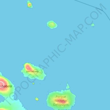
Nombre: Mapa topográfico Parroquia Santa Rosa, altitud, relieve.
Altitud media: 21 m
Altitud mínima: 0 m
Altitud máxima: 1.147 m
Haz una donación
Otros mapas topográficos
Haga clic en un mapa para ver su topografía, su altitud y su relieve.
Isla Pinzón
Ecuador > Galápagos > Cantón Santa Cruz
Pinzón or Pinzon Island (Spanish: Isla Pinzón) is an island in Ecuador's Galápagos Archipelago. It has no permanent population, an area of 18 square kilometers (6.9 sq mi), and a maximum elevation of 458 meters (1,503 ft). Home to giant Galápagos tortoises of the subspecies Chelonoidis duncanensis and…
Altitud media: 124 m
Haz una donación
Isla Plaza Sur
Ecuador > Galápagos > Cantón Santa Cruz
South Plaza (Spanish: Isla Plaza Sur) is a small island off the east coast of Santa Cruz in the Galápagos Islands. It has an area of 0.13 km2 and a maximum altitude of 23 metres.
Altitud media: 5 m
Haz una donación