
Mapa topográfico Texcoco de Mora
Mapa interactivo
Haga clic en el mapa para ver la altitud.
Texcoco de Mora
Se encuentra ubicado en la región oriente del Estado de México. Sus coordenadas geográficas son 19.30° N, 98.53° O. Colinda al norte con los municipios de Tepetlaoxtoc, Papalotla, Chiautla, y Chiconcuac; al sur con Chimalhuacán, Chicoloapan, e Ixtapaluca; al oeste con Atenco; y Nezahualcóyotl;y al este con los estados de Tlaxcala y Puebla. Oficialmente el municipio de Texcoco tiene una extensión territorial de 418,69 kilómetros cuadrados. La altitud de la cabecera municipal es de 2250 m s. n. m., su clima se considera templado semiseco, con una temperatura media anual de 15,9 °C y una precipitación media anual de 686 mm.
Acerca de este mapa
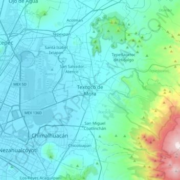
Nombre: Mapa topográfico Texcoco de Mora, altitud, relieve.
Lugar: Texcoco de Mora, Texcoco, Estado de México, 56100, México (19.35443 -99.04213 19.67443 -98.72213)
Altitud media: 2.448 m
Altitud mínima: 2.223 m
Altitud máxima: 4.121 m