
Gracias por apoyar a este sitio ❤️
Haz una donación
Haz una donación
Mapa topográfico Isla de Cedros
Haga clic en el mapa para ver la altitud.
Gracias por apoyar a este sitio ❤️
Haz una donación
Haz una donación
Acerca de este mapa
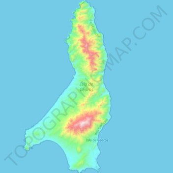
Nombre: Mapa topográfico Isla de Cedros, altitud, relieve.
Altitud media: 67 m
Altitud mínima: -3 m
Altitud máxima: 1.178 m
Gracias por apoyar a este sitio ❤️
Haz una donación
Haz una donación
Otros mapas topográficos
Haga clic en un mapa para ver su topografía, su altitud y su relieve.
Rodolfo Sánchez Taboada (Maneadero)
México > Baja California > Municipio de Ensenada > Ensenada
Altitud media: 76 m
Rodolfo Sánchez Taboada ( Maneadero )
México > Baja California > Municipio de Ensenada
Altitud media: 52 m
Gracias por apoyar a este sitio ❤️
Haz una donación
Haz una donación
Gracias por apoyar a este sitio ❤️
Haz una donación
Haz una donación