Mapa topográfico Ciénaga de Zapata
Mapa interactivo
Haga clic en el mapa para ver la altitud.
Acerca de este mapa
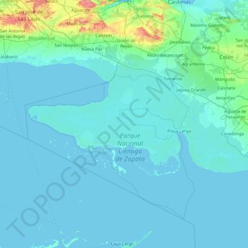
Nombre: Mapa topográfico Ciénaga de Zapata, altitud, relieve.
Lugar: Ciénaga de Zapata, Matanzas, Cuba (22.03770 -82.15773 22.61128 -80.59372)
Altitud media: 18 m
Altitud mínima: -2 m
Altitud máxima: 354 m
The Zapata Swamp lies between 22°01’ and 22°40’ N latitude and between 80°33’ and 82°09’ W longitude. The swamp in total is over one million acres (4,000 km²). Topographically, the maximum height above sea level is only about 10 meters with the top depth in below-sea-level coastal zones as follows: 2 meters in the salt-marsh area and from 1–600 meters in the sea coastal zone. Between May and October, the warmest season of the year, average temperature is 30 °C (86 °F). Between November and April, the coldest season of the year, the temperature on average is 20 °C (68 °F).
Otros mapas topográficos
Haga clic en un mapa para ver su topografía, su altitud y su relieve.
Yugoslavia
Yugoslavia, Reynold García (Pastorita), Peñas Altas, Ciudad de Matanzas, Matanzas, Cuba
Altitud media: 15 m
Zapata Swamp
Cuba > Matanzas > El Vinculo
Zapata Swamp, El Vinculo, Ciénaga de Zapata, Matanzas, Cuba
Altitud media: 18 m